How Many Meters Counts as Next to the Train, and What That Distance Costs


In Short
Advice
Key Highlights
- Thai law does not define next to the train for property advertising. The closest thing to an official benchmark is the 500 metre radius around a station used in the Bangkok comprehensive plan ministerial regulation of 2013 to grant construction incentives to developers.
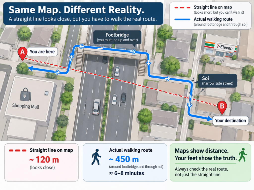
- The distance in a listing is usually a straight line drawn on a map. What you actually walk tends to be roughly 1.2 to 1.4 times longer, based on the route directness of urban pedestrian networks.
- Transit planning treats 400 metres as a 5 minute walk and 800 metres as a 10 minute walk, using a walking speed of about 80 metres per minute. Bangkok heat, footbridges and traffic lights all push the real number up.
- This report does not publish a single citywide price premium percentage, because the premium swings widely by station and price bracket. It gives you a repeatable method to calculate the premium for the station you care about.
- For most people the best value distance is not the shortest one. Price per square metre climbs faster than the walk time falls.
Why Is Next to the Train Harder to Pin Down Than It Sounds?
The short answer is that no Thai law defines the phrase for property advertising. Whoever writes the listing sets their own standard, and nobody is obliged to say which standard they used.
The nearest thing to a shared benchmark comes from an unrelated place. City planning rules use a 500 metre radius around a station to decide which land parcels get building incentives. That line was drawn for developers, not for the person who will make the walk twice a day. The result is that the same three words describe a unit with a covered link into the station and a unit that needs a footbridge crossing and a nine minute walk down a soi.
If you are moving to Bangkok from abroad, this matters more than it would at home. You are often choosing a unit from photographs before you have ever stood at that street corner, and the listing distance is the only number you have. This article separates where each benchmark comes from, then gives you a method to price the distance yourself.
Which Distance Benchmarks Are Actually Used in the Market?
City Planning Uses a 500 Metre Radius Around the Station
The ministerial regulation enforcing the Bangkok comprehensive plan of 2013 includes a floor area ratio bonus scheme. One qualifying condition is providing public parking within a 500 metre radius of named mass transit stations, with the extra building area capped at 30 square metres per additional parking space.
The draft fourth revision of the plan keeps the same geometry. It proposes letting buildings within 500 metres of a station, or 800 metres of an interchange such as Siam or Asok, cut their minimum parking requirement by 25 percent. That draft has not come into force as of the date of writing.
What a buyer should take from this is narrow but useful. The 500 metre figure tells you which plots the state considers station adjacent. It says nothing about whether the walk is pleasant, and it is measured as a radius on a map rather than along a footpath.
Developer Marketing Has No Common Standard at All
In listings, the same vocabulary covers wildly different realities. These are the phrases you will meet most often and what usually sits behind them.
| Phrase in the listing | What usually sits behind it |
| Connected to the station | Usually a covered link or an entrance within roughly 100 metres, and the only phrase that reliably matches what a reader expects |
| Near the BTS | The broadest phrase in the market, covering anything from 100 metres to well past 800 metres, so always ask for a number |
| A few minutes walk | States a time without stating a walking speed or a starting point, and the starting point is often the project boundary rather than the building entrance |
| Only 300 metres away | Almost always a straight line measured on satellite imagery, not the path your feet will take |
Residents Judge in Minutes, Not Metres
Transit oriented planning worldwide works in time rather than distance. Five minutes is treated as the walk people make without thinking about it, and ten minutes as the outer edge of what most people accept day after day. Converting with the walking speed planners use, roughly 1.2 to 1.4 metres per second or 72 to 84 metres per minute, gives about 400 metres for five minutes and about 800 metres for ten.
Those figures assume flat ground, shade and no waiting at crossings. Bangkok often delivers none of the three. Add a genuine allowance for footbridge stairs, signal waits and the difference between walking that stretch in December and walking it in April.
Which Walking Distance Definition Does This Report Use?
So that units can be compared, this report measures the walking route from the main building entrance to the nearest station exit, not a straight line between map pins. Four bands are used, which are up to 100 metres, 100 to 300 metres, 300 to 500 metres and over 500 metres.
How Far Apart Are Walking Distance and Straight Line Distance
Transport network research uses a measure called route directness, which is the ratio of the real route length to the straight line length. For urban pedestrian networks it commonly falls somewhere around 1.2 to 1.4, and it runs higher in districts built around dead end sois or cut through by canals and expressways.
In practice, a listing that says 300 metres as a straight line is likely to be a walk of roughly 360 to 420 metres. If the building sits on the opposite side of a main road and the only legal crossing is a footbridge, add more again. That gap is exactly why a unit can feel far on moving day when it looked close on the map.
How to Measure the Real Walk in Ten Minutes
- Open a maps app, set the start point at the building entrance rather than the project pin, and set the destination to the specific station exit you would use, for example Exit 3.
- Choose walking mode and note both the distance and the time the app returns.
- Read the route for major road crossings and footbridges. Each footbridge adds a minute or two of clock time and considerably more effort in the heat.
- Walk it once yourself at the hour you would actually travel, such as eight in the morning on a weekday, and time it. That number is the only one worth deciding on.
- Repeat for two or three other buildings around the same station so you have a basis for comparison rather than a single figure.
How Do You Calculate the Price Difference by Walking Distance?
This report deliberately does not publish one citywide premium percentage. The premium moves with the station, the price bracket and the age of the building, which makes a single average useless for any specific area. What helps more is a method you can run yourself in under an hour.
Five Steps to Gather the Data
- Work within a single station. Comparing across stations lets location variables in and the result becomes unreadable.
- Collect at least five sale listings per distance band, holding unit size roughly constant, for example one bedroom units of 28 to 35 square metres.
- Divide each asking price by usable area to get price per square metre for every listing.
- Use the median of each band rather than the mean, because one or two heavily renovated or corner units will drag an average off course.
- Calculate the premium against the furthest band as your base, by dividing the median of the band you care about by the median of the base band and subtracting one.
A Worked Example Using Illustrative Numbers
The numbers below are invented purely to show the arithmetic. They are not market data for any station.
- Suppose the median one bedroom beyond 500 metres sits at 100,000 baht per square metre. That is your base.
- Suppose the 300 to 500 metre band sits at 108,000 baht per square metre. The premium is 108,000 divided by 100,000 minus one, which is 8 percent.
- Suppose the 100 to 300 metre band sits at 118,000 baht per square metre. Against the same base that is 18 percent.
- Once every band has a figure, convert the gap into baht for a whole unit and set it against the walking minutes you save each day. That tells you what you are paying per minute of walk removed.
What Each Distance Band Typically Looks Like
The following patterns recur across Bangkok transit corridors. They are qualitative observations rather than published premium figures.
| Distance band | What you typically find |
| Up to 100 metres | Usually a covered link or a corner plot beside the station. Price per square metre is the highest in the area, the unit is the smallest you can buy for a given budget, and lower and middle floors take the most noise and station lighting |
| 100 to 300 metres | Where long term residents most often land. The walk is still a few minutes and the building has usually cleared the track line enough for the noise to drop noticeably |
| 300 to 500 metres | Price per square metre eases visibly while the walk stays inside the ten minute frame. This band usually buys a larger unit for the same money |
| Over 500 metres | Price keeps easing, but travel behaviour changes. Most people start taking a motorbike taxi or driving instead of walking, so that recurring cost belongs in your comparison |
Why Does the Rental Premium Behave Differently From the Sale Premium?
Tenants decide on daily time cost rather than long term value, so walking distance carries more weight in rent than in sale price, and it shows up faster. Leases are renegotiated every year, while sale prices reflect longer term market expectations and move more slowly.
To measure the rental gap, run the same five steps but divide by monthly rent per square metre, and control for two extra variables. Furnishing level and floor height both influence rent more than they influence sale price, so leaving them uncontrolled will distort the result.
One further difference matters if you are letting the unit out. Units close to a station tend to sit vacant for shorter periods between tenants, and vacancy affects annual income at least as much as the monthly rent does. That is a general pattern rather than a guarantee that a unit near a station will always be occupied.
Which Distance Gives the Best Value for Price and Travel Time?
The most honest answer is that the best value distance for most people is not the shortest one. Price per square metre climbs steeply as you approach a station, while the walking time you save falls one minute at a time. Past a certain point the money paid per minute of walk removed stops making sense.
To find that point for yourself, take the whole unit price gap between two bands, divide it by the minutes saved per trip, then multiply by the trips you genuinely make in a year. If you work from home three days a week your trip count is far lower than a five day commuter, and the answer shifts towards the farther band immediately.
Three factors deserve extra weight in Bangkok. The first is whether the route has shade or leaves you in full sun. The second is how often you come home late, because lighting and footfall on that stretch matter far more after dark. The third is whether the area floods in the rainy season, which changes the walk the whole neighbourhood is willing to make.
If you are new to the city, one more factor belongs on the list. Many people arriving in Bangkok rent for a year before buying anything, and a year of living with a particular walk teaches you more about your own tolerance than any calculation will. Treating the first lease as a test of the distance, not only of the unit, is a reasonable way to spend it.
What Are the Limits of This Dataset?
- No citywide premium percentage is published here, because no cross checkable dataset measured from real walking distance was available. Premium figures quoted elsewhere are usually derived from a straight line radius or from the name of the nearest station, which is a different definition entirely.
- Prices used in the method above are asking prices, not transacted prices. Closing prices are typically lower and are not public, so the calculated premium reflects the supply side.
- Walking routes returned by mapping apps do not always exist on the ground. Project fences, links that open only during business hours and sois that do not connect all break the assumption.
- Variables that affect price as much as distance remain uncontrolled, including building age, developer reputation, the quality of juristic person management and unit orientation. Controlling only for distance gives a coarse picture rather than a final answer.
- The planning rules cited here can change. The draft fourth revision is not in force as of the date of writing, so confirm the version currently in effect with the Bangkok Metropolitan Administration Department of City Planning and Urban Development before relying on it.
Frequently Asked Questions About How Many Meters Counts as Next to the Train
How many metres from the train counts as being next to the train
There is no legal definition for advertising purposes. The closest official benchmark is the 500 metre radius around a station used in the Bangkok comprehensive plan ministerial regulation of 2013 to grant construction incentives. For someone who will live there, a more useful line is a real walking distance of no more than 300 metres, which is roughly a four minute walk.
Is the distance in a listing a walking distance or a straight line
In most cases it is a straight line measured on a map. Ask the agent directly which two points were measured, then verify it by setting a walking route from the building entrance to the station exit you would use. The result is usually about 1.2 to 1.4 times the advertised figure.
How long does it take to walk 500 metres
At the walking speed used in planning work, roughly 72 to 84 metres per minute, 500 metres takes about six to seven minutes on flat ground with no signal waits. In Bangkok, add time for footbridges and crossings, and allow for heat, which genuinely slows people down.
Is the unit closest to the station always the best buy
Not usually. The closest units carry the highest price per square metre and give you the least floor area for a given budget. Work out what you are paying per minute of walk removed, then weigh it against the trips you really make each year. People who work from home part of the week often do better a band farther out with a larger unit.
Should I compare buildings by distance or by walking time
Use walking time as the primary measure and keep distance as a secondary one, because time already absorbs footbridges, crossings and signal waits. The best version of this is still walking the route yourself at the hour you would normally travel, with a stopwatch running.
Summary
Nobody owns the phrase next to the train. The 500 metre figure you hear repeated comes from planning law written for developers, not for the person making the walk twice a day. What you can actually decide on is the walking route from the building entrance to the exit you would use, and the time you clock yourself at the hour you would travel.
Once you have that number, run the premium calculation in this article for the station you are considering. It tells you what you are paying for each minute of walking removed, and only then can you judge whether that trade fits how you live.
If you want real units to pull price per square metre from, browse verified listings for condos to rent in Bangkok on PropertyScout and start collecting data band by band. For a head start, there is a station by station guide to condo prices and rents along the BTS, and a resident's account of whether living beside the Skytrain is worth it in practice.
If you would rather have someone gather it with you, work with an agent who speaks your language and they can put the station level comparison together from the first conversation.
Prices and availability change and nothing here is guaranteed. Property information is general guidance only. This content is not legal, tax or financial advice.
Sources. Ministerial regulation enforcing the Bangkok comprehensive plan of 2013, Bangkok Metropolitan Administration Department of City Planning and Urban Development · Draft fourth revision of the Bangkok comprehensive plan, not yet in force · Five minute and ten minute walk standards from transit oriented development planning practice · Route directness values for urban pedestrian networks from transport geography research. All sources checked in August 2026.
FAQs
Lorem ipsum dolor sit amet, consectetur adipiscing elit. Suspendisse varius enim in eros elementum tristique.

Explore More Topics
Free real estate resources and tips on how to capitalise